The NSF-ICF currently stores over 22,000 meters of firn and ice core collected from various locations in Greenland, Antarctica, and North America. Sample requests are coordinated through the Science Management Office at UNH. For information on how to access the cores, please see Services. The following cores are in the NSF-ICF inventory.
The Basin cores (BSN# on the map) are a series of 10.2 cm diameter firn cores collected to ~20 m depth across southern Greenland in 2003 as a part of PARCA. There is only a small section of core remaining from each core.
The Camp Century ice core is a 10.8 cm diameter core drilled during 1963-1966 to 1390 m depth. Portions of the Camp Century core are at the NSF-ICF, however, NSF had no involvement in the collection of the core itself. Discontinuous sections are at the NSF-ICF, with some sections archived in Copenhagen. There are also two shallower cores drilled during 1961 and 1962 in inventory, and both of those cores are on the de-accession list.
In 1974, CRREL recovered a 12.7 cm diameter, 404 m long ice core at Crete as part of the international Greenland Ice Sheet Program (GISP). CRREL was the lead US laboratory (Hansen and Langway, co-PIs) for GISP. The Crete ice core was drilled by Lyle Hansen, John Rand, and Robert Bigl using CRREL’s thermal drill. The core is on the de-accession list.
D4 is a 10.2 cm diameter, 146 m long core drilled in 2003 to investigate annual accumulation over recent centuries in central Greenland. The ice core was analyzed by CFA by Joe McConnell and annually dated based on multiple seasonal markers, including hydrogen peroxide (H2O2), total sulfur, lead, and sea-salt and dust tracers (for example, Na, Mg, Ca). The period of record in the D4 core is 1734-2003 (McConnell and others, 2019). There is only a small section of core remaining in the archive.
D5 is a 10.2 cm diameter, 148 m long core drilled in 2003 to investigate annual accumulation over recent centuries in central Greenland. The ice core was analyzed by CFA by Joe McConnell and annually dated based on multiple seasonal markers, including hydrogen peroxide (H2O2), total sulfur, lead, and sea-salt and dust tracers (for example, Na, Mg, Ca). The period of record in the D5 core is 1765-2003 (McConnell and others, 2019). There is only a small section of core remaining in the archive.
The Dye-3 deep ice core (10.2 cm diameter; 2037 m long) was drilled from 1979-1981 as an international venture called the Greenland Ice Sheet Program (GISP), involving groups from Denmark, Switzerland, and the United States. The drilling was conducted with the new Danish ISTUK electromechanical drill. The drilling fluid was kerosene (Jet A1) and perchloroethylene (PCE). Drilling reached 225 m in 1979, 901 m in 1980, and the bed at 2037 m in 1981. Silty ice was found at a depth of 2013 m. Discontinuous sections are archived at the NSF-ICF, and other sections are archived in Copenhagen.
In late 1988, the Office of Polar Programs (OPP, formerly the Division of Polar Programs) of the U.S. National Science Foundation (NSF) officially initiated the Greenland Ice Sheet Project Two (GISP2) project. It was developed as the first in a series of integrated studies, administered by OPP under its Arctic System Science (ARCSS) program, an initiative focusing on environmental change in the Arctic. On 1 July 1993, after five years of drilling, GISP2 penetrated through the ice sheet and 1.55 meters into bedrock, recovering an ice core to 3053.44 meters depth.
A series of 10.2 cm diameter, ~20 m deep firn cores drilled in 1995 as a part of PARCA. There is only a small section remaining from each core. There was also a 10.2 cm diameter, 146 m long ice core drilled in 1995 for PARCA called Humboldt BII (HumB2), but that core has been consumed entirely.
In 1973, CRREL recovered a 12.7 cm diameter, 404 m long ice core at Milcent as part of the international Greenland Ice Sheet Program (GISP). CRREL was the lead US laboratory (Hansen and Langway, co-PIs) for GISP. The Milcenet ice core was drilled by Lyle Hansen, John Rand, and Robert Bigl using CRREL’s thermal drill. The core is on the de-accession list. Only a small section of the core remains in the archive.
A 10.2 cm diameter, 82 m long core drilled in 2003 near Summit, Greenland, to investigate annual accumulation over recent centuries in central Greenland. The ice core was analyzed by CFA by Joe McConnell and annually dated based on multiple seasonal markers, including hydrogen peroxide (H2O2), total sulfur, lead, and sea-salt and dust tracers (for example, Na, Mg, Ca). The period of record in the Sandy core is 1753-2003 (Banta and McConnell, 2007). Only a small section of the core remains in the archive.
As part of the site-selection activities for the Greenland Ice Sheet Program 2 (GISP2) deep drilling, two 100 mm diameter cores at Site A were drilled in 1985 using the electromechanical PICO 4-Inch Drill. Only one of the cores remains (core 2; core ID: SITE A2) in the ICF archive. The core is 100 m long, pore close-off occurs at about 75-80 m depth, and the accumulation rate is about 290 mm a-1 ice. The core is not continuous and is on the de-accession list.
The ICF archive contains one 10.4 cm diameter, 213 m long core drilled in 2013 for Joe McConnell (Tunu2013). The period of record in the Tunu2013 core is 268-2013 CE (Grieman and others, 2018), and the Tunu2013 ice core site has an average accumulation rate of 0.100 m w.e. yr-1 (Sigl and others, 2015). The archive also contains a series of shallower (15 m depth) cores drilled at Tunu in 1996 for Konrad Steffen. The mean annual temperature at the Tunu-N weather station is -27.5 C. Only small sections of each core remain in the archive.
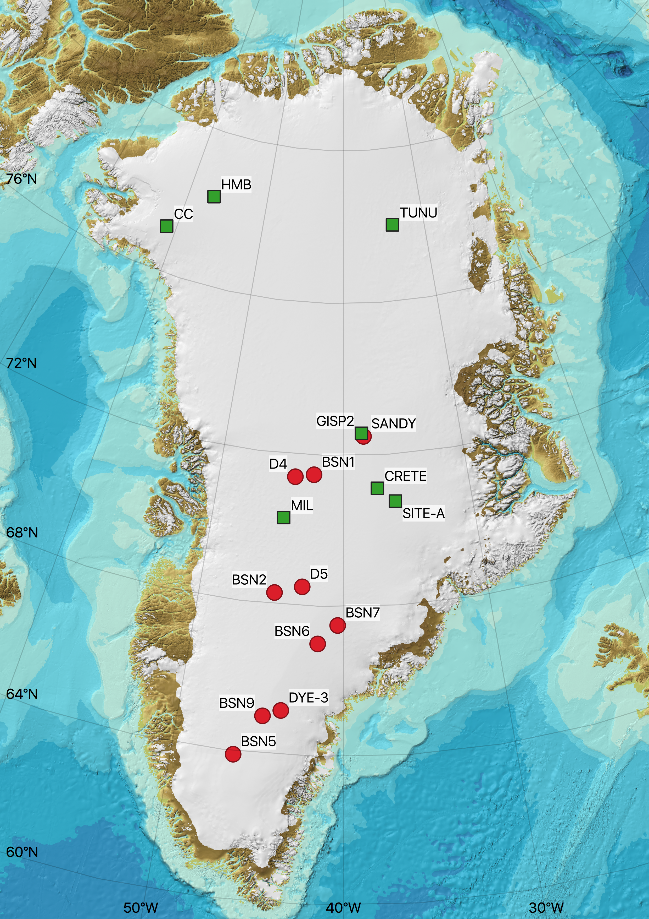
Map of Greenland showing the location of cores in the NSF-ICF inventory. Red circles indicate locations without deaccessed cores. Green squares indicate locations with deaccessed cores. BSN#=Basin; CC=Camp Century; HMB=Humboldt. Click on the map to open a larger version.
Large-diameter (24.1 cm) cores drilled with the Blue Ice Drill are stored at the NSF-ICF. Smaller diameter (3-inch) cores are also archived. The cores are from the blue ice areas at Allan Hills. The Center for Oldest Ice Exploration (COLDEX) is managing access to the Allan Hills ice cores archived at the NSF-ICF, including the Allan Hills cores collected prior to the COLDEX STC funding. For information on the Allan Hills cores available, please contact COLDEX at coldexinfo at oregonstate dot edu.
The Beacon Valley and Mullins Valley cores are not "typical" ice cores since the glacier contains some ice/sediment mixes below the surface. The cores were collected in blue ice areas by David Marchant and Michael Bender in 2009. For information on the cores available, please contact the NSF-ICF Science Management Office.
The Bentley Shot Hole cores collected in 1994 and 1995 were cores of opportunity as the result of geophysical studies in central West Antarctica. Four cores ranging in depths between 50 to 90 meters were collected. The sites lie on a 200 km traverse gaining elevation from 950 to 1930 meters. The Bentley Shot Hole cores are referred to as Central West Antarctica (CWA) cores in the Reusch and others (1999) paper (BEN2 = Site A; BEN3 = Site C; BEN4 = Site D; BEN5 = Site B). Some cores have a continuous archive remaining.
The Byrd deep ice core was drilled in 1968 by CRREL and originally stored in Buffalo, NY, and later transferred to NICL (now the NSF-ICF). The archived core is not continuous.
The Dominion Range is located along the edge of the East Antarctic ice sheet, approximately 500 km from the South Pole and 120 km from the Ross Ice Shelf, at the confluence of Beardmore and Mill Glaciers. During the 1984 austral summer, the University of New Hampshire undertook a field program on the plateau of the Dominion Range. Studies conducted during the field program included: (1) development of an ice drainage map for the study region, (2) radio-echo sounding in the general region of the drill site, (3) surface and detailed snowpit (6 meters and 1-2 meters deep) sampling, and (4) collection of a 201-meter core (drilled by the University of Nebraska's Polar Ice Coring Office) including on-site examination of the physical condition of the core, temperature, and density. The 201 m long, 10 cm diameter, core has been heavily sampled and the remaining archive at the ICF is not continuous.
The Ross Ice Shelf Project (RISP) began in 1973 and lasted six field seasons. One of the primary goals for RISP was to drill a hole through the Ross Ice Shelf to study the ice, the ocean, and the ocean floor beneath the ice shelf. In late November 1974, during the second field season, the camp at J-9 (82.375S, 168.626W) on the southeastern Ross Ice Shelf was established. RISP drilling started in 1976/77 with a PICO wireline drill that drilled a hole 187 mm in diameter to retrieve a 60 mm core. The borehole was left dry of drilling fluid to keep it clean, but as a consequence, the drill became stuck in the borehole at 90 m above the base (420 m) during a drill crew changeover. Subsequent attempts during the 1977/78 season to melt out the wireline drill with hot water failed. During the 1978/79 season, a lightweight Russian electrothermal drill, using ethanol as antifreeze, provided continuous core to the ice- shelf bottom and access to the ocean (Bentley and Koci, 2007).
A discontinuous archive of the top 104 m of the dry drilled 1976 J-9 core (NSF-ICF core ID: J-9Bern) resides at the ICF. The 1976 core was originally archived at the Central Ice Core Storage Facility at SUNY, Buffalo, and later transferred to the NSF-ICF. Samples from the 1976 core were taken in the 1980s, but no sampling has occurred since.
A 255 meter long, 9.8 cm diameter, core drilled near the front of the Ross Ice Shelf, Antarctica, during the International Geophysical Year. The core was dry drilled with a Failing rotary well-drilling rig to 249 m. The hole was then filled with diesel fuel for pressure balance and drilling continued. Drilling stopped on 5 December 1958 at 255 m, 2 or 3 m above the base of the ice, when sea water entered the hole and rose to 188 m. The archive at NSF-ICF is not continuous.
During the 2003/04 Antarctic field season, PI Todd Sowers and colleagues collected cores from the blue ice areas at Mount Moulton. The core in the NSF-ICF archive is not continuous; however, large samples are available. The lat/long for the core is a best-estimate based on published results from other cores in the area. Mount Moulton is in Marie Byrd Land, West Antarctica, and its blue ice area offers an ice record dating back beyond 140,000 years.
The 175 m long, 10 cm diameter, ice core was collected during the austral summer of 1988-1989 and contains information on chemistry, Pb- 210 profiles, density profiles and temperature profiles. A second core 150 meters long was also collected but is no longer in the ICF inventory. Snow pits were also dug and sampled by the Glacier Research Group (GRG) at the University of New Hampshire. The firn/ice transition at Newall Glacier is at ~39 meters depth and the mean annual temperature is -29 C. (Mayewski and others, 1995). The core is on the de-accession list and the remaining archive is not continuous.
The RIDS (Ross ice drainage system) cores are annually dated 10 cm diameter cores drilled in 1995 from the Marie Byrd Land region of West Antarctica. The period of record in the RIDS95A core is 1831-1995. The period of record in the RIDS95B core is 1925-1995. The period of record in the RIDS95C core is 1905-1995 (Kreutz and others, 2000). The RIDS95A archive is not continuous.
Siple Dome is located in West Antarctica on the Siple Coast between the Kamb and Bindschadler Ice Streams (former Ice Streams C and D) at approximately 81.65° S, 148.81° W.
1994/95 Site Reconnaissance
During the 1994/95 field season, a 150 m core was drilled ~3 km north-northeast of the summit of Siple Dome (ICF Core ID: SDM 94). Portions of the core are in the NSF-ICF archive.
1996/97 to 1998/99 Deep Core (SDMA)
The deep Siple Dome ice core (ICF Core ID: SDMA) was drilled to bedrock (1004 m depth) during the 1996-1998 austral summers. SDMA depths attained were 154 m in 1996/97, 351 m in 1997/98, and the bed at 1004 m in 1998/99 (Bentley and Koci, 2007). There was no attempt to core the bed. The deep SDMA and shallower (100 m) SDMB ice cores were drilled 10 m apart from one another (Dunbar and others, 2003). SDMA has been sampled fairly intensely and core quality is always an issue in the deeper areas.
Shallow Cores
A series of shallow cores (B-H) were collected in a transect across Siple Dome during the 1996/97 field season to explore the spatial variability of various climatic and meteorological signals. Cores B, C, D and I are from the summit of Siple Dome, cores E and G are from the north flank of the dome facing the Pacific Ocean, and cores F and H are from the south flank of the dome facing inland (Jones and others, 2014).
South Pole Ice Core (SPICE; SPC14)
On January 23, 2016, the South Pole Ice Core (SPICEcore) project reached its final depth of 1751 meters (5745 feet; 1.1 miles), extending more than 54,000 years into the past. The 9.8 cm diameter ice core was drilled during the 2014/15 field season (0 to 736 meters) and 2015/16 field season (736 to 1751 meters) using the U.S. Intermediate Depth Drill. The South Pole ice core is the highest-resolution interior East Antarctic ice core that extends into the last glacial period and is the first record longer than 3000 years collected south of 82° latitude. For more information about the South Pole ice core, visit the project’s website.
2004 Cores
During the 2004/05 austral summer, six cores were drilled at a site 4.7 km west of the Amundsen‐Scott South Pole Station for Jihong Cole-Dai. Four of the cores were ~40 m long firn cores, one core was 182 m in depth (SP04-C5), and one core was 102 m in depth (SP04C6). None of the cores have a continuous archive remaining, and all six of the cores are on the de-accession list.
SPRESSO
The SPRESSO (South Pole Remote Earth Science and Seismological Observatory) core (ICF core ID: SPRESSO02) was drilled by ICDS during the 2002/03 Antarctic field season at 89.93°S, 144.39°W to a depth of 291.26 meters. The core was sampled by the United States International Trans Antarctic Scientific Expedition (ITASE) team and subsequently archived at the NSF-ICF. The core has subsequently been heavily sampled, but there still is a continuous (albeit small) archive remaining. No drilling fluid was used during the drilling of the core.
2001 Cores
As a result of a firn pumping experiment at the South Pole by Mark Battle and Michael Bender, two ~123 meter cores (SP01-1 and SP01-2) were drilled at the Amundsen-Scott South Pole Station, Antarctica. Both cores were shipped to the ICF. Neither core has a continuous archive remaining, and both cores are on the de-accession list.
Taylor Dome is an ice dome west of the Transantarctic Mountains on the polar plateau of East Antarctica.
The 554 m deep Taylor Dome ice core (ICF Core ID: Taylor Dome M3C1) was recovered in 1993/94 using the PICO 132 mm drill in an n-butyl-acetate filled hole. The core was drilled to bedrock and basal sediment (60 mm) and rock debris were also recovered. Actual drilling took 17days, working around the clock (Bentley and Koci, 2007). Two shallow cores were also collected, and the archive from both shallow cores is not continuous.
Large-diameter (24.1 cm) cores drilled with the Blue Ice Drill were collected in 2013 along a transect on the Taylor Glacier by PI Sarah Aciego and transferred to the University of Michigan. PI Aciego moved from the University of Michigan and the cores were transferred to the NSF-ICF in 2018. The cores are between 50-100 cm in length and from ~6 meters deep. The transect is well-dated and the cores range from ~44,000 to 9,000 yBP. Download the Taylor Glacier BID spreadsheet for a list of the cores in the NSF-ICF inventory. For more information, please contact the NSF-ICF Science Management Office by email at nsf.icf.smo @unh.edu.
The Upstream C (now called the Kamb Ice Stream) core was collected in 1996 for physical properties. Small sections of the core remain but the core is not continuous.
Vostok is in proper stratigraphic order to about 3350 m depth. From 3350-3536 m depth, the ice is clean glacial/refrozen lake ice and is not in stratigraphic order. Discontinuous sections are available in the NSF-ICF archive. Several sections from other cores drilled at Vostok are also in the NSF-ICF archive.
On December 1, 2011, the West Antarctic Ice Sheet (WAIS) Divide ice core project, funded by the National Science Foundation (NSF), reached its final depth of 3405 meters (11,171 feet; over 2 miles), recovering the longest U.S. ice core to date from the polar regions. The WAIS Divide ice core was recovered at a field camp in the center of West Antarctica, 1,040 kilometers (650 miles) from the geographic South Pole, where the ice is more than 3,460 meters (two miles) thick. The drill site is characterized by a combination of moderate ice accumulation rate, thick ice, and other characteristics that preserve detailed information on past environmental conditions during the last 68,000 years. The drilling of the ice core ceased 50 meters (164 feet) above the contact between the ice and the underlying rock, to avoid contaminating a possible water layer at the ice-rock contact. In the WAIS Divide ice core, each of the past 30,000 years of snowfall can be identified in individual layers of ice, with lower temporal resolution records extending to 68,000 years before present. The WAIS Divide ice core has provided the first Southern Hemisphere climate and greenhouse gas records of comparable time resolution and duration to the Greenland deep ice cores, enabling detailed comparison of environmental conditions between the northern and southern hemispheres, and the study of greenhouse gas concentrations in the paleo-atmosphere, with a greater level of detail than previously possible.
There is one 12.2 cm diameter deep (3405 meters long) ice core (WDC06A) and several shallow smaller-diameter cores available in the ICF inventory.
REPLICATE CORES
In December, 2012, the researchers re-entered the deep borehole and successfully drilled through the wall of the 3405-meter deep parent hole and collected a total of 285 meters of additional "replicate" core (10.8 cm diameter) from five of the most interesting time periods in the WAIS Divide climate record. Deviation #1 corresponds to AIM8 and the Laschamp Event. Deviation #2 corresponds to the 18 ka event. Deviation #3 corresponds to the Bølling-Allerød event. Deviation #4 corresponds to the Younger Dryas event. Deviation #5 corresponds (again) to the 18 ka event.
| Deviation # | Coring Start Depth (m) | Full Diameter By (m) | Coring End Depth (m) |
|---|---|---|---|
| 1 | 3001.55 | 3006.16 | 3100.26 |
| 2 | 2416.70 | 2420.02 | 2469.49 |
| 3 | 2221.00 | 2226.16 | 2290.80 |
| 4 | 1952.00 | 1956.90 | 2000.20 |
| 5 | 2414.50 | 2420.02 | 2428.74 |
Windless Bight is located on the Ross Ice Shelf, about 20 kilometers away from the U.S. Antarctic Program’s McMurdo Station. Two cores were drilled in 1996 at Windless Bight, one to 44 m depth and the second to 80 m depth. Both cores have a continuous archive and both cores are on the de-accession list. There is no additional information on these cores.
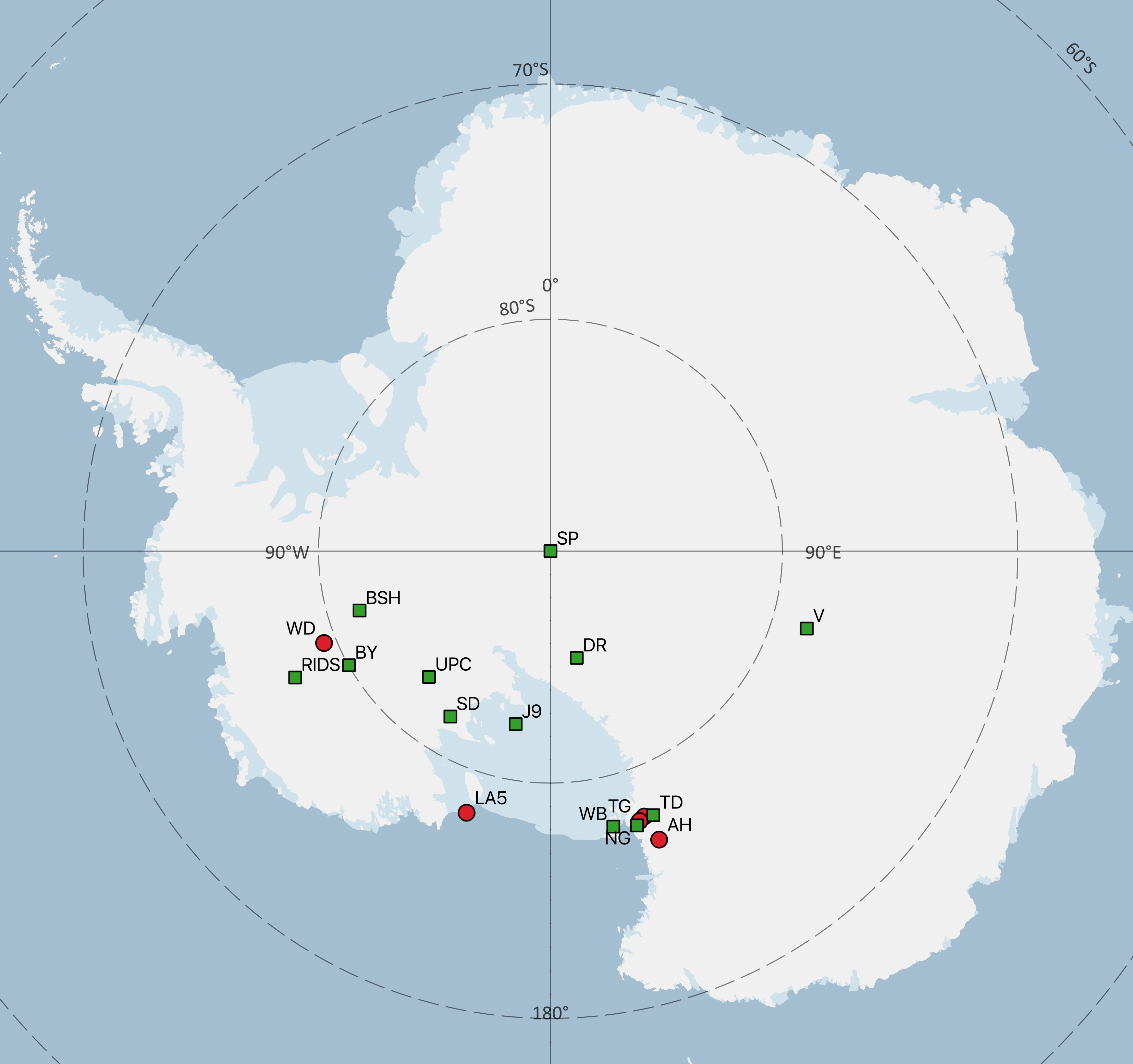
Map of Antarctica showing the location of cores in the NSF-ICF inventory. Red circles indicate locations without deaccessed cores. Green squares indicate locations with deaccessed cores. AH=Allan Hills; BSH=Bentley Shot Holes; BY=Byrd; DR=Dominion Range; LA5=Little America 5; NG=Newall Glacier; SD=Siple Dome; TD=Taylor Dome; TG=Taylor Glacier; UPC=Upstream C; V=Vostok; WD=WAIS Divide; WB=Windless Bight. Click on the map to open a larger version.
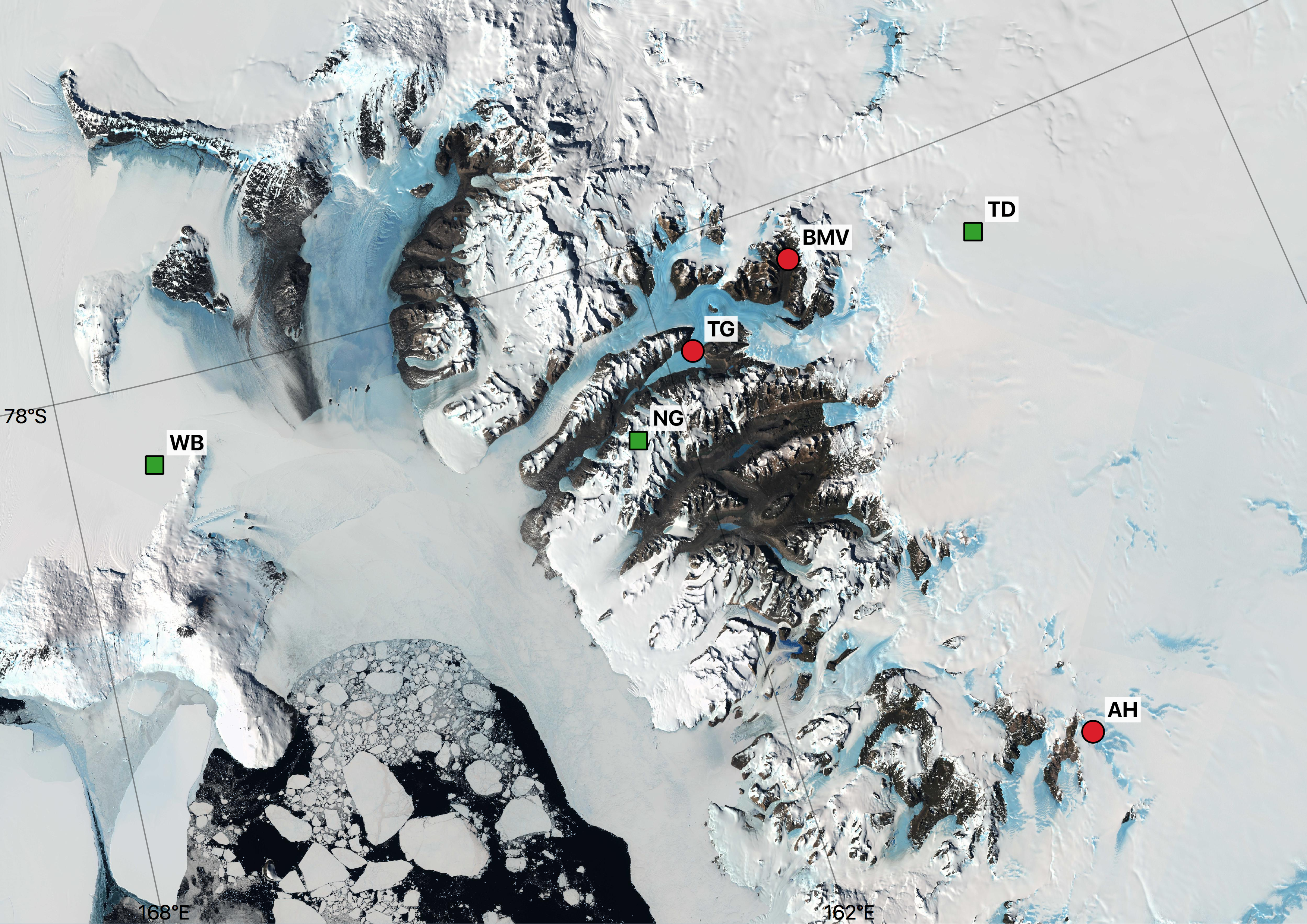
Map of Antarctica showing the location of cores in the NSF-ICF inventory. Red circles indicate locations without deaccessed cores. Green squares indicate locations with deaccessed cores. AH=Allan Hills; BMV=Beacon and Mullins Valley; NG=Newall Glacier; TD=Taylor Dome; TG=Taylor Glacier; WB=Windless Bight. Click on the map to open a larger version.
An 8 cm diameter, 208 m long surface-to-bedrock core dry drilled in May-June 2013 from the summit plateau (3900 m) of Mt. Hunter, located within Denali National Park in the central Alaska Range. The site is characterized by a high snow accumulation rate (1.4‐m w.e.) and cold mean annual temperature (-17 °C) (Polashenski and others, 2018). The period of record in the core is ~810-2012 CE (Winski and others, 2017).
The Fremont Glacier is located in the Wind River Range of Wyoming. Two cores are in the ICF inventory, one drilled in 1998 (FRE98-4) and the other drilled in 1991 (FRE91-1). Both cores are 8 cm in diameter and were drilled by the USGS. The period of record in the 1998 core is ~1746-1998 AD. The period of record in the 1991 core is ~1717-1991 AD. Limited samples remain from both cores.
A 10.4 cm, 152-meter long core (McCallUC core) drilled in 2008 from the McCall Glacier, Alaska, for PI Matt Nolan. The core was drilled using an electromechanical drill until water was reached ~70 m below the surface, at which point a thermal drill was used. At 152 meters, drillers hit a rock at what the team believes was the bottom of the glacier, based on radar measurements of ice depth. The 152-meter long core was stored in Fairbanks for ~8 months and then transported to the NSF-ICF in February 2009, where it is currently archived. Portions of two shallow cores drilled elsewhere on McCall Glacier are also in inventory. McCall Glacier is located in northeastern Alaska in the Romanzof Mountains in the eastern Brooks Range and is ~230 km northeast of Toolik.
South Cascade Glacier is a small valley glacier in the North Cascades Range, Washington. The 7.6 cm diameter, 158 m long core (SOCAS2) was collected in 1994 by USGS scientists. The period of record in the core is ~1840-1991.
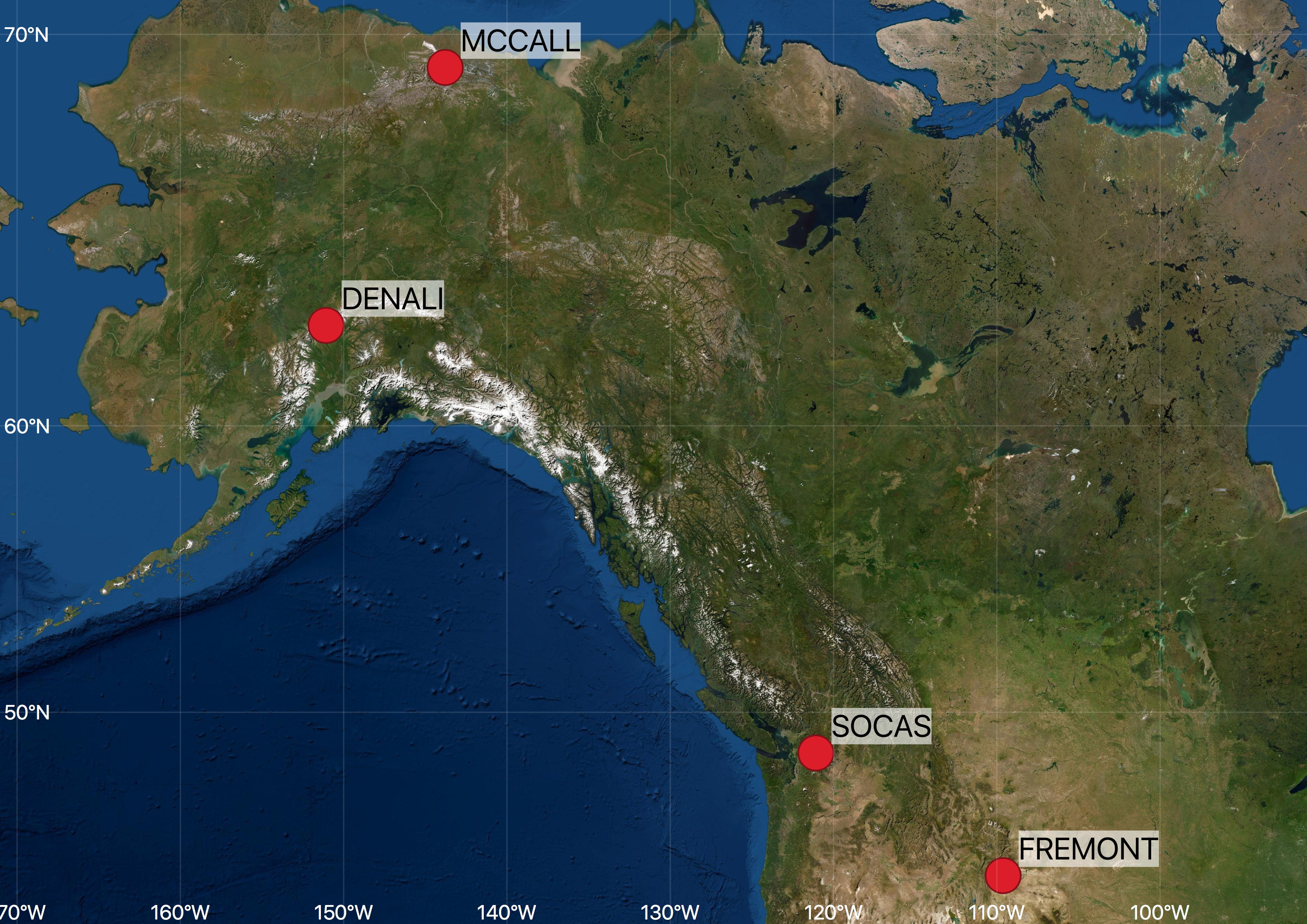
Map of North America showing the location of cores in the NSF-ICF inventory. SOCAS=South Cascade. Click on the map to open a larger version.